


Summary (English)
From September to November 2004 and from February to April 2005, the Šibenik City Museum conducted rescue archaeological excavation along the Poljana maršala Tita, which is a central town square (cadastral parcel no. 5794, cadastral municipality of Šibenik). The cause for the archaeological excavation was the relocation of the “Juraj Šižgorić” City Library to the new facility, former Dom JNA (Yugoslav People’s Army Hall) on the city square and the rearrangement of the area between the library and the square.
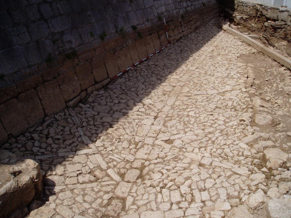
In the immediate vicinity, within the Robert Visiani Park, a part of the 14th-century ramparts has been preserved and archaeological excavations in 1991 and 1997 also uncovered parts of the 15th-century city fortifications: the rampart and the Round Tower with casemates (Ćuzela 2005, Pavičić 2001). Therefore, further north, in front of the new city library, elements of the eastern defence fortifications of the City of Šibenik were to be expected, (based on historical sources and graphics from the 17th and 18th centuries), specifically the Bernardi bastion, built around 1660, during the Candian War. The bastion had the shape of an irregular pentagon and probably covered the entire upper part of today’s park. Therefore it is not surprising that, within the given frame of trench 1, only a part of the north wall in the length of 21.80 meters was excavated. In trench 2, located north from trench 1 (two trenches were separated by ten-meter wide access to the library), at a depth of sixty centimetres (13.50 m above sea level), a 15-meter-long cobblestone street was discovered. Its upper surface is paved with irregular stones, laid on an about half a meter high stone embankment. Almost the entire length of the street is divided into two lanes by a central row of square stone blocks, and the surface of both lanes is decorated with a zigzag stone arrangement. The southern edge of the street leans against a rampart built at the same time as the Bernardi bastion. On the south side, the street is bounded by two walls. Since one of the walls, as well as the street, leans (was subsequently built) on the preserved segment of the rampart built at the same time as the Bernardi bastion, the architectural elements and the street excavated in trench 2 should be dated after the second half of the 17th century, and, according to the numismatic evidence, not later than the early 19th century. The excavated remains in trench 2 probably represent the access way to the former main city entrance through the walls of the front fortress (E. Podrug 2006, Hrvatski arheološki godišnjak 2/2005, 340–341).
- Emil Podrug
Director
- Ivan Pedišić
Team
- Emil Podrug
- Toni Brajković
- Željko Krnčević
- Tomislav Pavičić
Research Body
- Muzej grada Šibenika
Funding Body
- Grad Šibenik
![[PDF]](download.php?file=11421.jpg "Download")